
North Dakota Map
|
 |
 |
Where Is North Dakota?
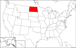
The Peace Garden State of North Dakota is colorized in red on the adjoining map. North Dakota is bounded by the Canadian Province of Manitoba on the north, by South Dakota on the south, and by Minnesota on the east. The State is bordered by Montana to the west and by the Canadian Province of Saskatchewan to the northwest.
North Dakota Maps
North Dakota is the 17th largest state in the United States, covering a land area of 68,976 square miles (178,648 square kilometers). The state is divided into fifty-three counties. This North Dakota map site features road maps, topographical maps, and relief maps of North Dakota. The detailed, scrollable road map displays North Dakota counties, cities, and towns as well as Interstate, U.S., and North Dakota state highways. The pannable, scalable North Dakota street map can be zoomed in to show local streets and detailed imagery.
North Dakota Highway Map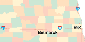 Click on the highway map thumbnail
to view a scalable North Dakota road map. |
ND Topo Map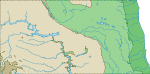 Click map to enlarge.
|
ND Relief Map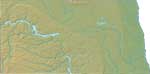 Click map to enlarge.
|
The detailed North Dakota map and the regional North Dakota map display cities, roads, rivers, and lakes as well as terrain features. The detailed map shows only the State of North Dakota, while the regional map shows North Dakota and the surrounding region.
North Dakota Infrastructure > North Dakota Airports
In 2005, the population of North Dakota was estimated at 634,605, which is about 9.2 people per square mile. In 2010, North Dakota's population rose to 672,591 people. More recently, in the 2020 census, the North Dakota population was 779,094. The state's Interstate Highways include I-29 and I-94.
North Dakota Topography
Dakota was named after the Dakota tribe of Sioux Indians. Dakota is the Sioux word for "friend". Both North Dakota and South Dakota were admitted to statehood in the USA on November 2, 1889. This low-lying state is drained by the Red and Missouri Rivers. Its most notable topographical feature, the Badlands, is located in western North Dakota.
For North Dakota travel and tourism information, visit the official North Dakota tourism site and North Dakota Atlas.
Other Maps of North Dakota
This North Dakota reference map shows major cities, roads, railroads, and physical features in North Dakota.Several map publishing companies offer printed maps of North Dakota. For example, Omni Resources offers several maps of North Dakota that feature points of interest, airports, and parks, as well as selected local attractions and insets of major North Dakota cities.
All rights reserved.
Certain maps hereon are © Map Resources or Digital Wisdom.
To facilitate browsing, certain external links will open in new windows.
North-Dakota-Map.org Editor, State Maps, PO Box 828, Barnegat, NJ 08005.